English

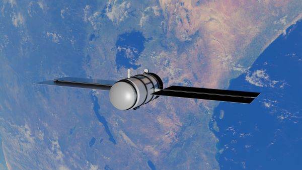
Europe is strengthening its weather monitoring capacity with the new generation of Meteosat satellites, designed to improve forecasts and track phenomena such as storms, fires, droughts and air pollution. The launch of the MTG-I2 satellite completes the first operational configuration of the Meteosat Third Generation programme and gives European meteorologists access to more accurate and faster data on the evolution of the atmosphere.
The MTG-I2 satellite was launched last week from the European Space Centre in French Guiana, on an Ariane 6 rocket. According to the European Space Agency (ESA), the new satellite will join the devices already in orbit as part of the Meteosat Third Generation programme, built in cooperation with the European organisation for the exploitation of meteorological satellites, informs EUMETSAT (European Organisation for the Exploitation of Meteorological Satellites). ESA states that the full program will include six satellites, four Imager and two Sounder, designed to ensure the continuity of European weather observations for the next two decades. The stakes are linked to the ability to identify dangerous weather phenomena more quickly. Unlike traditional weather images, the new instruments allow for more frequent monitoring and at a higher resolution of evolving atmospheric systems.
• Storms, tracked in near real time
One of the main instruments of the new generation is the Flexible Combined Imager (FCI). According to ESA, it can scan certain regions of Europe and North Africa at intervals of about 2.5 minutes, providing a detailed picture of the evolution of clouds and weather systems. The capacity is important in the case of strong storms, which can develop in a very short time. The successive data allow meteorologists to track the formation and intensification of convective clouds and improve warnings of severe phenomena, according to information published by ESA. For the population, the benefit may be represented by faster warnings. For the economy, however, the stakes are wider: transport, agriculture, energy production and infrastructure can be affected by extreme events, and anticipating them can reduce losses.
• Satellites also track fires
The new European infrastructure is also important for monitoring wildfires. EUMETSAT shows that the Flexible Combined Imager instrument can be used to identify and monitor fires, as well as to observe aerosols and volcanic ash. Satellite data allows to follow the evolution of outbreaks and the atmospheric conditions that favor their expansion. The usefulness of the system has already been demonstrated during the fire season in Europe. EUMETSAT used satellite observations to monitor the fires that affected the continent in 2025, providing information on the evolution of the outbreaks and the resulting emissions.
As wildfires increasingly affect agricultural areas, forests, infrastructure and tourist areas, space-based monitoring is becoming an important tool for authorities and emergency services.
• Drought, observed from space
Another area in which satellite data is gaining importance is drought monitoring. The temperature of the land surface, the evolution of clouds, humidity and other characteristics of the atmosphere can be monitored by the new generation Meteosat instruments. In addition, Sounder satellites provide information on the distribution of temperature and humidity in different layers of the atmosphere. According to ESA, this data can contribute to improving weather models and anticipating the evolution of extreme phenomena. For agriculture, such information can be used to assess vegetation conditions and the risk of water stress. For authorities, the data is relevant in managing water resources and preparing measures for periods of prolonged drought.
• Lightning, a new indicator of storm intensification
The Meteosat Third Generation system also brings an expanded capability to monitor electrical activity in the atmosphere. The Lightning Imager instrument detects lightning continuously over very large areas. EUMETSAT states that the data can be used to identify and track developing storms. Electrical activity inside cloud formations can provide clues about the intensification of a storm. The information can be integrated into warning systems and weather forecast models.
• A second satellite provides a three-dimensional image of the atmosphere
MTG-I2 is not the only important component of the new infrastructure. In July 2026, MTG-S1, the first Sounder satellite of the program The Meteosat Third Generation satellite has been declared operational. According to ESA, the satellite is designed to obtain a three-dimensional image of the atmosphere and provide information on temperature, humidity and air composition. One of its instruments is the Infrared Sounder, which allows the measurement of atmospheric structure vertically. ESA says that this data can help improve forecasts and monitor severe weather events. MTG-S1 also has an instrument designed to monitor the composition of the atmosphere, which allows the tracking of pollutants and other components relevant to air quality.
• Extreme weather is becoming an economic problem
Investments in meteorological infrastructure are directly linked to the increasing costs generated by extreme events. A severe storm can affect transport and energy networks, drought can reduce agricultural production, and fires can destroy forest areas, homes and infrastructure. At the same time, extreme events put pressure on the insurance industry and public budgets.
In this context, the ability to better predict weather events can have significant economic value. An earlier warning can allow operators to protect their equipment, transport companies to change routes, and authorities to prepare interventions or evacuations. Thus, weather satellites are no longer just an infrastructure for weather forecasting. They become part of the European risk management system.














 Euro
Euro Dolar SUA
 Franc elveţian
 Liră sterlină
 Gram de aur